Senyar Swamps Sumatra
On November 25, 2025, Cyclone Senyar made history by becoming only the second tropical cyclone ever recorded in the Strait of Malacca, a region typically too close to the equator for such storms to develop due to the weak Coriolis effect. This unusual weather event intensified from a tropical depression and made landfall on Sumatra, Indonesia, shortly after forming. As the cyclone traversed the island, it unleashed an unprecedented deluge, with satellite estimates from NASA’s Global Precipitation Measurement mission reporting nearly 400 millimeters (16 inches) of rain in some areas. The combination of heavy rainfall and the region’s mountainous terrain resulted in devastating flash floods and landslides, severely impacting local communities.
The aftermath of Cyclone Senyar was catastrophic, compounded by an earthquake that struck just two days later on November 27. Reports indicate that the flooding led to hundreds of fatalities and displaced over 700,000 people, with the Indonesian authorities confirming at least several hundred deaths as of December 4. The flooding was exacerbated by loose timber piles that turned into dangerous debris, further damaging infrastructure and homes. The situation was dire not only in Indonesia; surrounding countries including Sri Lanka, Thailand, Vietnam, and Malaysia were also grappling with their own weather-related disasters, with the United Nations estimating that over 10.8 million people across the region were affected, and more than 1.2 million displaced due to flooding.
NASA’s Earth Observatory documented the extensive impact of the cyclone with imagery captured by the Operational Land Imager-2 on Landsat 9, showing the inundated town of Lhoksukon in North Sumatra. The muddy, sediment-filled waters illustrate the scale of the disaster that struck the region, highlighting the urgent need for humanitarian assistance and disaster relief. As Southeast Asia continues to confront the aftermath of Cyclone Senyar, the event serves as a stark reminder of the unpredictable nature of climate phenomena and the growing vulnerability of communities in the face of extreme weather events.
https://www.youtube.com/watch?v=QtGOUvKHsms
EO
Science
Earth Observatory
Senyar Swamps Sumatra
Earth
Earth Observatory
Image of the Day
EO Explorer
Topics
All Topics
Atmosphere
Land
Heat & Radiation
Life on Earth
Human Dimensions
Natural Events
Oceans
Remote Sensing Technology
Snow & Ice
Water
More Content
Collections
Global Maps
World of Change
Articles
EO Kids
About
About Us
Subscribe
Contact Us
November 30, 2025
Tropical cyclones almost never form over the Strait of Malacca. The narrow waterway separating Peninsular Malaysia from the Indonesian island of Sumatra sits so close to the equator that the
Coriolis effect
is usually too weak to allow storms to rotate enough to organize into cyclones. But on November 25, 2025, meteorologists watched as a tropical depression intensified into Cyclone Senyar—just the second documented case of a tropical cyclone forming in the strait.
Hemmed in by land on both sides, Senyar made landfall in Sumatra later that day as it
made a U-turn
and headed east toward Malaysia. As the slow-moving storm passed over Sumatra’s mountainous terrain, it dropped nearly 400 millimeters (16 inches) of rain in many areas, according to
satellite-based estimates
from NASA’s Global Precipitation Measurement (
GPM
) mission. (Due to the averaging of the satellite data, local rainfall amounts may differ when measured from the ground.)
The torrent caused extensive flash floods and landslides in Sumatra’s rugged terrain. Streams and rivers rapidly overflowed with sediment-laden, debris-filled waters that swept through villages, cities, and towns. News reports suggest that the damage was worsened by
an earthquake
that struck on November 27 and the abundance of
loose piles of timber
in the region that became destructive battering rams in high water. As of December 4, Indonesian authorities
reported
several hundred deaths and more than 700,000 displaced people.
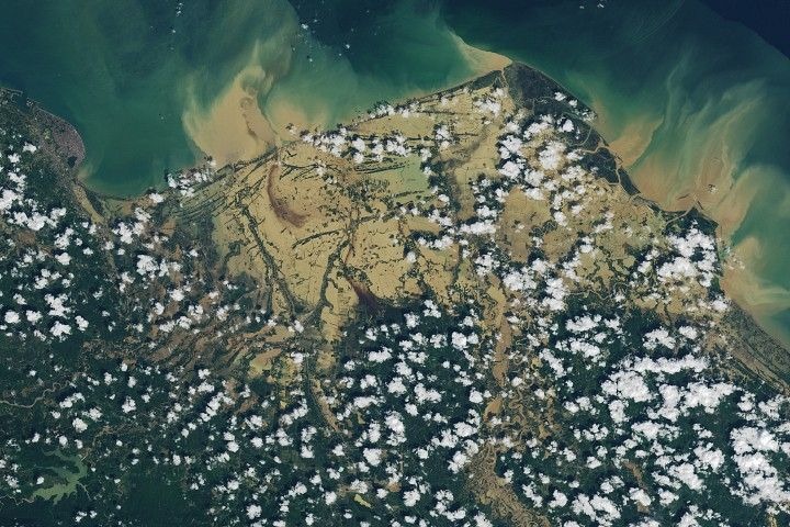
The
OLI-2
(Operational Land Imager-2) on
Landsat 9
captured this image of flooding in Aceh and North Sumatra provinces on November 30, 2025. Muddy sediment-filled water appears to have swamped much of Lhoksukon, a town of 40,000 people, and several surrounding villages.
Other tropical cyclones and monsoon rains hitting Sri Lanka, Thailand, Malaysia, and Vietnam at roughly the same time have also caused extensive destruction in the broader region. According to
one estimate
from the United Nations Office for the Coordination of Humanitarian Affairs, flooding has affected more than 10.8 million people in the region and displaced more than 1.2 million.
NASA Earth Observatory image by Lauren Dauphin, using Landsat data from the
U.S. Geological Survey
. Story by Adam Voiland.
References & Resources
BNPB (2025)
News Index
. Accessed December 4, 2025.
India Today (2025, December 2)
What made Cyclone Senyar a once-in-a-century weather anomaly in Malacca Strait
. Accessed December 4, 2025.
The Malaysian Reserve
(2025, December 3)
Death toll from floods, landslides in Indonesia rises to 811
. Accessed December 4, 2025.
NASA Earthdata (2025)
Tropical Cyclones
. Accessed December 4, 2025.
The New York Times
(2025, December 3)
Where Floodwaters Turned Piles of Timber Into Floating Battering Rams
. Accessed December 4, 2025.
ReliefWeb (2025, December 3)
Asia and the Pacific: Southeast and South Asia Cyclones and Floods Humanitarian Snapshot (Covering 17 November to 3 December 2025
. Accessed December 4, 2025.
Tsunami and Disasters Mitigation Research Center (2025, November 29)
Extreme Rainfall from Tropical Cyclone Senyar Triggers Widespread Flooding and Infrastructure Damage Across Aceh
. Accessed December 4, 2025.
Downloads
View All
November 30, 2025
JPEG (8.43 MB)
You may also be interested in:
Stay up-to-date with the latest content from NASA as we explore the universe and discover more about our home planet.
Monsoon Rains Flood Pakistan
3 min read
Heavy rains and flooding across the country since June 2025 have displaced millions of people, devastated infrastructure, and submerged farmland.
Article
Imelda and Humberto Crowd the Atlantic
3 min read
The tropical cyclones are close enough in proximity that they may influence one another.
Article
Rokan River Painted by the Tides
2 min read
Tides and sediment form brushstroke-like patterns across the river estuary in eastern Sumatra.
Article
1
2
3
4
Next
Keep Exploring
Discover More from NASA Earth Science
Subscribe to Earth Observatory Newsletters
Subscribe to the Earth Observatory and get the Earth in your inbox.
Earth Observatory Image of the Day
NASA’s Earth Observatory brings you the Earth, every day, with in-depth stories and stunning imagery.
Explore Earth Science
Earth Science Data