NASA Fuels Discovery from Earth to Sky: One Crayon at a Time
NASA’s innovative “Color-a-Pixel” initiative is revolutionizing the way visitors engage with Earth and space science at national parks and other public lands. Launched through a collaboration between the NASA Earth Science Education Collaborative (NESEC) and the Earth to Sky (ETS) partnership, this program transforms complex satellite imagery into accessible art projects. By using simple coloring activities, visitors can connect with NASA’s scientific data in a hands-on, interactive manner. The process involves selecting satellite images from missions such as Landsat or the Lunar Reconnaissance Orbiter and converting them into large, numbered posters that correspond to Crayola crayon colors. This allows participants to collaboratively color in the images, revealing the stories that these satellite data tell about our planet and beyond.
The Color-a-Pixel activity has been successfully implemented at various public events, including the Death Valley Dark Sky Festival and the Park After Dark event in Minnesota. These gatherings not only provide a creative outlet but also serve as platforms for park rangers and educators to discuss significant scientific concepts and environmental changes. For instance, while coloring topographical maps of the Moon, participants engage in discussions about lunar geology and the stark differences between the Moon’s near and far sides. This interactive approach helps demystify satellite imagery, emphasizing that every pixel represents valuable data contributing to our understanding of Earth and other celestial bodies.
The collaboration between NESEC and Earth to Sky exemplifies how simple, engaging activities can enhance educational experiences and foster a deeper appreciation for science among diverse audiences. With over 2,000 educators and interpreters involved, the initiative reaches millions of visitors each year, making NASA’s Earth science missions accessible and relevant to everyday life. As environmental challenges continue to impact public lands, the Color-a-Pixel activity not only educates participants about these issues but also invites them to contribute to citizen science projects, bridging the gap between scientific research and community involvement. Looking forward, this colorful collaboration aims to expand its reach, ensuring that the wonders of NASA’s science continue to inspire and educate future generations, one crayon at a time.
Explore This Section
Science
Science Activation
NASA Fuels Discovery from…
Overview
Learning Resources
Science Activation Teams
SME Map
Opportunities
More
Science Activation Stories
Citizen Science
6 min read
NASA Fuels Discovery from Earth to Sky: One Crayon at a Time
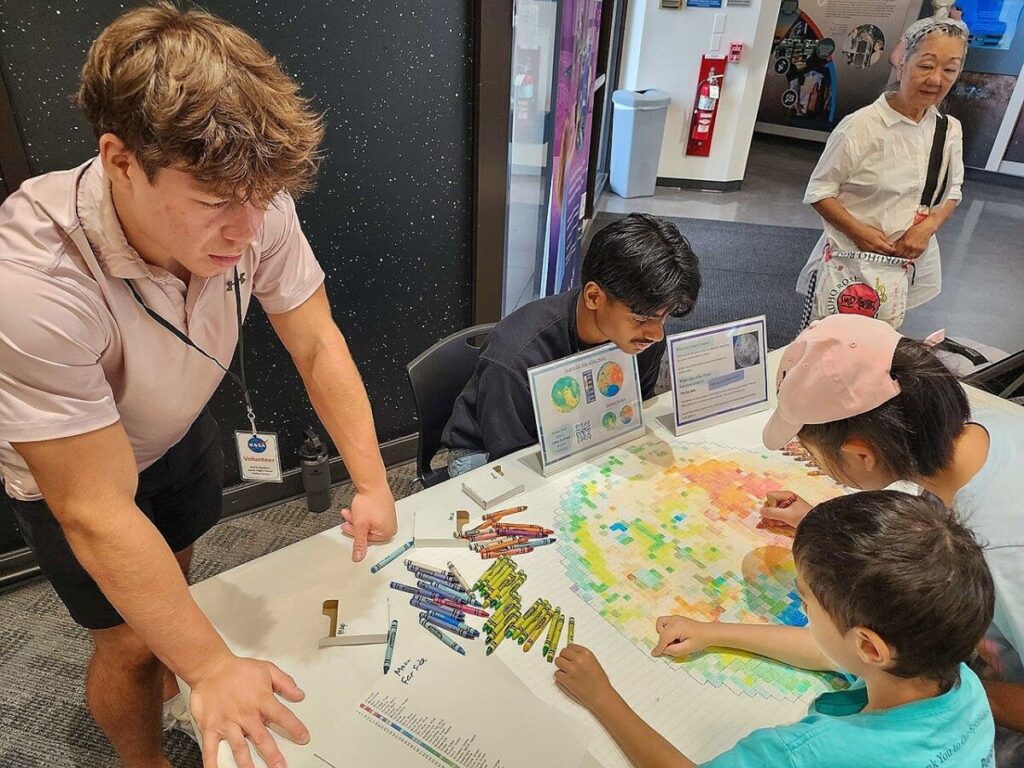
Student interns help kids color in data to learn more about the far side of the Moon while visiting the Goddard Space Flight Center Visitor Center.
Photo Credit: NASA Earth to Sky
A collaboration between the NASA Earth Science Education Collaborative (NESEC) and Earth to Sky (ETS) – an exciting, growing partnership between NASA, the National Park Service, and other federal, state, and local organizations – is facilitating the implementation of a simple, yet incredibly effective activity that will help millions of national park visitors connect with NASA Earth and space science.
The
Color-a-Pixel
activity, developed by NESEC, transforms complex satellite imagery into accessible, collaborative art projects. Incorporating this simple technique into ETS science communication training programs demonstrates to park interpreters and outdoor educators how NASA’s view from space can enhance millions of visitor experiences at parks, refuges, and nature centers.
“This low-tech activity is powerful because of its simplicity,” explains ETS Space Science Coordinator Brandi Stewart, “All you have to do is pick up a crayon, follow the easy number guides, and discover the stories that NASA satellites are telling us about our world and beyond.”
The Color-a-Pixel activity begins with selecting satellite imagery from NASA missions like Landsat, the Mars Reconnaissance Orbiter (MRO), or the Lunar Reconnaissance Orbiter (LRO). Using technology developed by NESEC’s lead organization, the Institute for Global Environmental Strategies, these images are converted into a 3’ by 2’ poster of numbered squares, each corresponding to one of 120 standard Crayola crayon colors.
Earth to Sky demonstrates the magnetic appeal of this activity by setting it up for the rangers and educators during workshops. With a bit of explanation, participants immediately jump in, eager to reveal the imagery and data shown through the pixels.
“It becomes a group mission that, by the end of the training, the image will be fully colored in and complete. It’s been a great teambuilding and stress-relieving activity for our participants,” states Geneviève de Messières, Earth to Sky Program Lead.
When applied to public lands communication efforts, this activity becomes a tool for interpretive messaging. While visitors work on completing the image, park rangers can weave in scientific concepts, environmental change stories, and space exploration connections. This activity also drives home that satellite imagery is more than just a pretty picture – each pixel is also data that scientists use to better understand Earth and other worlds throughout our solar system.
Bringing Space Down to Earth
Some ways that Earth to Sky has implemented the activity at special events on public lands include:
Death Valley Dark Sky Festival, California: Visitors were invited to color Landsat imagery of Earth’s Badwater Basin and MRO imagery of Mars’ Belva Crater. As they colored, Earth to Sky outreach specialists made connections between finding signs of water on the dry landscapes in both locations.
Park After Dark, Minnesota: During this urban event hosted by Mississippi River & National Recreation Area in Minneapolis St. Paul, attendees worked together to color topographical maps of both the Moon’s familiar near side and its mysterious far side, using data from NASA’s Lunar Reconnaissance Orbiter. The striking differences that emerged through their coloring sparked questions about why the Moon’s two hemispheres appear so dramatically different, leading to rich discussions about lunar formation and geological change.
Patuxent Wildlife Refuge Open House, Maryland: Just miles from the urban centers of Baltimore and Washington DC, the Color-a-Pixel activity helped local community members visualize something they could feel but not easily see: the refuge’s role as a “cool island” in an urban heat landscape. Visitors colored Landsat imagery of the refuge and surrounding neighborhoods while examining heat maps showing temperature differences between developed areas and the protected green space. The activity helped residents understand the refuge’s importance beyond wildlife habitat.
All of these activities are available on the
Institute for Global Environmental Strategies (IGES) website
in a pre-generated format ready for printing.
A Colorful Collaboration
The collaboration between NESEC and Earth to Sky brings complex scientific concepts to diverse audiences in engaging and relevant ways. Earth to Sky’s community of practice –now including more than 2,000 interpreters and environmental educators – reaches millions of visitors annually across the country’s parks, refuges, and nature centers.
Theresa Schwerin, who leads NESEC, noted that Color-a-Pixel originally started as a simple idea for a tabletop activity to use at conferences and public events. “I wanted something hands-on that could draw people in and start conversations as simple as ‘these beautiful NASA images from space are data’ and talk about different NASA missions and how they are relevant to people’s lives. There’s also an opportunity to invite the public to contribute to NASA science by participating in citizen science projects … [some of which] can fill in the details of the pixels with information that complements NASA’s view from space.”
Andrew Clark, a data scientist and engineer at IGES, created the Color-a-Pixel poster generator, which has gone through several iterations to make it more effective. Schwerin noted, “I’ve used this at several public events. Kids will jump right in, with parents watching over their shoulders. Soon enough, the entire family is coloring together and asking questions about the image and NASA. I am thrilled about our collaboration with Earth to Sky that is taking this even further.”
As environmental challenges increasingly affect public lands, this collaboration helps visitors understand these issues through NASA’s unique perspective from above. The activity also introduces learners of all ages to the broader value of NASA’s Earth science missions alongside its more well-known space exploration endeavors.
Continuing to Color Outside the Lines
Looking ahead, the Earth to Sky partnership plans to continue using this activity in each new place they host a training. Most recently, Earth to Sky shared the activity with 417 visitors to the Goddard Space Flight Center Visitor Center, where local families colored in topographical Moon maps to prepare for
International Observe the Moon Night
. Additionally, a recording of a recent Color-a-Pixel webinar with NESEC’s Theresa Schwerin is available on the Earth to Sky website for interpreters and informal educators interested in implementing this place-based activity.
Free registration is required to access this (and dozens of other) webinar recordings
.
The success of this collaboration demonstrates how seemingly simple activities – enhanced with NASA science – can create meaningful learning experiences that resonate with visitors long after they leave a park or refuge.
For interpreters, educators, or NASA enthusiasts interested in bringing the Color-a-Pixel activity to their own sites or events, pre-generated activities are available in the gallery at:
.
NASA science is helping humanity discover new perspectives on both our home planet and the universe beyond, one crayon at a time. Learn more about how Science Activation connects NASA science experts, real content, and experiences with community leaders to do science in ways that activate minds and promote deeper understanding of our world and beyond:
https://science.nasa.gov/learn/about-science-activation/
.
Share
Details
Last Updated
Nov 20, 2025
Editor
NASA Science Editorial Team
Related Terms
Science Activation
Explore More
5 min read
Helio Highlights: October 2025
Since we all have a relationship with the Sun, it is important to learn about…
Article
2 months ago
4 min read
From City Lights to Moonlight: NASA Training Shows How Urban Parks Can Connect Communities with Space Science
Article
2 months ago
3 min read
NASA Helps Connect Astronomers and Community Colleges Across the Nation
Article
2 months ago
Keep Exploring
Discover More Topics From NASA
James Webb Space Telescope
Webb is the premier observatory of the next decade, serving thousands of astronomers worldwide. It studies every phase in the…
Perseverance Rover
This rover and its aerial sidekick were assigned to study the geology of Mars and seek signs of ancient microbial…
Parker Solar Probe
On a mission to “touch the Sun,” NASA’s Parker Solar Probe became the first spacecraft to fly through the corona…
Juno
NASA’s Juno spacecraft entered orbit around Jupiter in 2016, the first explorer to peer below the planet’s dense clouds to…